
The ancient settlement of Tharros is a place out of time. Already Phoenician port, with its promontory guaranteed the safe landing in all conditions of sea and wind. Today it is an archaeological area of great interest.
It is located at the end of the Sinis peninsula in the Gulf of Oristano, it is bordered to the north by the hill of Su Murru Mannu, to the west by the Tower of San Giovanni and to the south by the isthmus towards Capo San Marco. Founded towards the end of the 8th century BC, it was abandoned around 1070 A.D. to give rise to Aristiane, the present Oristano. Tharros is the ideal cultural compendium to the wonderful beaches of Sinis.
The archaeological site of Tharros
The archaeological area of Tharros is an open-air museum, with ongoing excavations continually revealing new details about the past of this ancient city. Visitors will be fascinated by the natural beauty of the place, located in front of one of the most beautiful seas in Italy, and by the rich stratified history of Tharros, visible in the archaeological remains that have been preserved over the millennia.
Nuragic age and Punic period – Phoenician
The ancient city of Tharros preserves stratified archaeological remains, including and superimposed through different eras: from the Nuragic age to the Phoenician-Punic period, until the Roman era. There are also visible remains dating back to the medieval period.
The peninsula of Capo San Marco has traces of settlements of the Nuragic Age, with finds of the Middle Bronze Age (1600-1300 BC) found on the top of the hill of Su Muru Mannu (the great nose), under the Phoenician-Punic tophet. The investigations revealed circular huts, indicating a nuragic village inhabited at least until the eighth century B.C.
The tophet was a sacred Phoenician-Punic place dedicated to religious rites and sacrifices, often associated with the deposition of the ashes of the deceased.
Recent research indicates that Tharros, as a Phoenician city, arose towards the end of the 7th century BC. Today, nothing remains of the original center due to subsequent urban interventions. The city, divided into two main sectors, includes the hill of Su Muru Mannu and the base of the hills of Su Muru Mannu and San Giovanni. Among them are blocks of houses and public buildings, delimited by the Roman road system, still partly to be explored.
The Phoenician and Punic necropolis of Tharros, north and south of the town, testify to the ancient city. The northern necropolis, near San Giovanni di Sinis, contains Punic graves with caisson and Phoenician to incineration, while the southern necropolis, damaged in the nineteenth century, is composed of underground Punic tombs with access to a well.
San Giovanni, a hamlet of Cabras south of the Sinis peninsula protected by the marine area, is located along the road that leads to the ancient city of Tharros and, further south, to the scenic Cape San Marco.
Roman period
On top of the hill of Su Muru Mannu stands the most preserved fortification of Sardinia, characterized by imposing walls of basalt superimposed dry, with a wall on the western and northern sides. A postierla, closed around 50 BC, was on the western side, decorated with regular blocks of light sandstone, ensuring a hidden emergency passage away from the main gates.
In front of this wall extends another wall, built with the same technique, forming a long moat. Initially considered a Punic fortification, recent investigations suggest that the present appearance dates back to a Roman Republican renovation of the 2nd century B.C.
After the middle of the 1st century BC, the moat was partially filled and abandoned. In front of the post was built a small funeral chamber and the moat was occupied by a Roman necropolis of the early Imperial Age with dark graves. These burials, characteristic of the Roman era between the first and fourth centuries AD, have a vaulted roof reminiscent of a dome. The single or collective dark tombs were part of larger necropolis and symbolized heaven or eternal habitation.
The area behind the fortification wall, formerly a nuragic village, was used in the Phoenician and Punic Ages as a tophet for the deposition of urns with cremated remains and carved stelae. In the Roman Age, the area saw unspecified buildings and many stelae were reused for the basement of a building. To the south of the tofet there is an undeveloped clearing, once connected to the access to the city, now identified as a small amphitheater surrounded by terraced land. On the southern slopes of the hill of Su Muru Mannu, Roman remains show two basalt streets with a central sewer, dividing the area into three blocks. There are houses in the upper part and public buildings, including a spa, in the lower area. The road system of the full Imperial Age defines Tharros in distinct areas, with sacred structures towards the sea and houses towards the mountain. At the northwest corner of the triangle, a square housed a possible lost shrine and the castellum aquae, a large reservoir with a public fountain. The triangular block included various sacred buildings, such as the Temple of the Punic semi-columns, later covered by buildings of the second century A.D. that have not been preserved.
Next to the Temple of the semi-columns, a space open towards the street contains foundations and remains of two sacred environments with mosaic floors of the third century AD.
Opposite, remains of a possible temple of the first century B.C. for a podium with columns rebuilt in a modern way. This was the urban heart of Tharros, with the main Roman public buildings. On the sea side, in addition to the temple described above, there is the large thermal building “Terme n. 1”, poorly preserved but with heated rooms still visible. In the late Roman period, the northern part of the baths was incorporated into an early Christian basilica with hexagonal baptismal font from the 5th-6th centuries AD.
To the south, another well-preserved spa structure, the Terme di Convento Vecchio, perhaps later used as a refuge for monks, is highlighted by the presence of a Byzantine tomb. The public area of the Roman city extends to the south, where the aforementioned baths are located. Part of the eastern sector of the spa has been eroded by the sea, but the building maintains a good elevation, showing the typical plan of the spa: dressing room, room for cold baths and passage to heated environments. Built shortly after 200 AD, it reflects the building fervour of the Roman cities of Sardinia of that period.
At the origin of the Terme di Convento Vecchio, on the slope of the hill of San Giovanni, important building works were carried out both during the Late Punic and Roman Ages. Between the third and second centuries BC, a flight of steps was built leading to Temple K with a portico. During the Roman Empire, between the second and third centuries AD, the portico was divided into rooms, the entrance of the temple closed and materials of the first building, including a punic inscription, were reused.
The remaining area of Tharros was occupied by Roman and late Roman dwellings, with an accurate division into neighborhoods and an efficient sewerage and water system. The housing structures passed to agricultural productive uses.
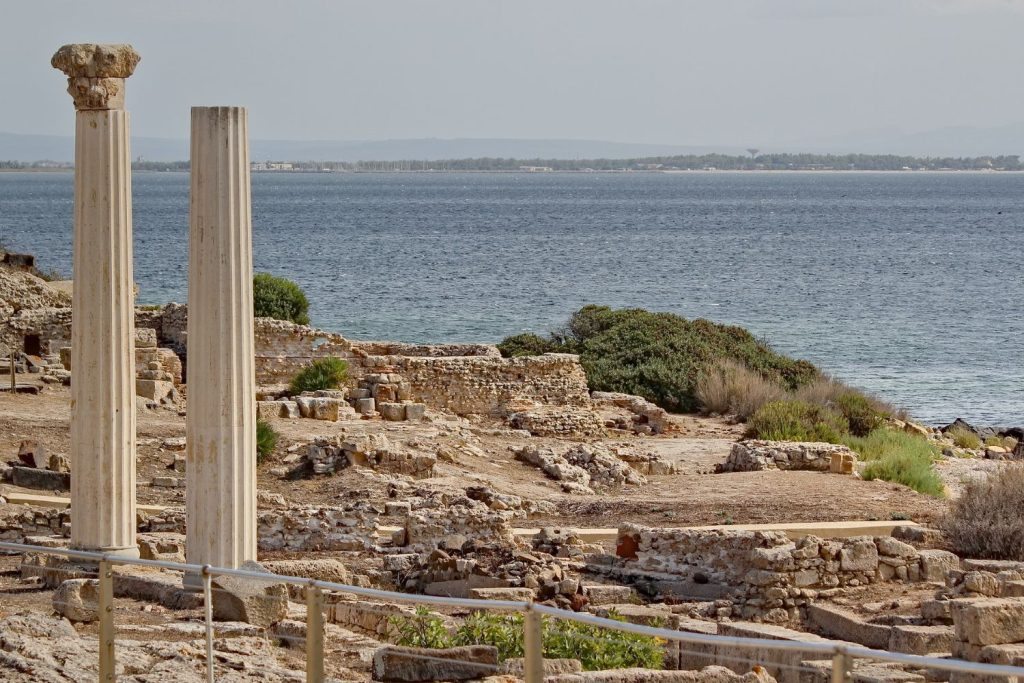
Foto : Pixabay
Decline and abandonment of Tharros
During the Vandal Age, the public quarter was renovated with new buildings of worship.
In the Byzantine Age, Tharros began to decline, maintaining a minimal utility until the Middle Ages as a maritime port, although of uncertain location. The presence of medieval settlements in Tharros is confirmed by the church of San Giovanni di Sinis, built in the 6th-7th century A.D. and renovated in the 11th century. Located near the fortifications of Su Muru Mannu, it is similar to other medieval religious settlements such as the church of Sant’Efisio in Pula. Despite urban decline, the territory remained vulnerable to Saracen raids, and the Tower of San Giovanni was erected for protection under Philip II of Spain, mentioned in documents of 1591.
Finally, in 107q0, the inhabitants of Tharros abandoned the city to found Aristiane, the modern Oristano.
Brief history of Tharros
Tharros (Latin Tarrae, Ancient Greek Thàrras) is an archaeological site in the municipality of Cabras, province of Oristano, Sardinia. Located south of the Sinis peninsula, near Cape San Marco, the name has proto-Sardinian origin and connects to the Mediterranean root Tarr-, similar to Tarracina (Lazio) and Tarraco (Hispania Citerior).
Founded by the Phoenicians in the 8th century B.C. near a Nuragic village of the Bronze Age, Su Muru Mannu, the site includes a Phoenician religious building. The inhabitants of the nuragic village peacefully left the area and collaborated with the Phoenicians to build the new city.
Under the rule of Carthage, Tharros was fortified, enlarged and prospered thanks to trade with Africa, the Iberian Peninsula and Massalia (present-day Marseille).
During this period, Tharros may have been the provincial capital of Carthage.
Conquered by Rome in 238 BC, immediately after the First Punic War, Tharros was the scene of an anti-Roman revolt led by Ampsicora in 215 BC.
Ampsicora (or Ampiscora) is a historical figure of the 3rd century BC, known for his role during the Second Punic War. He was a Sardinian nobleman and leader of the resistance against the Roman invasion of the island.
During the Roman imperial age (the period of the history of Rome from 31 or 27 B.C. to 476 A.D., the year of the fall of the Western Roman Empire) the city was renovated with the construction of baths, aqueducts and a road network paved in basalt. It gained the status of a community of Roman citizens.
After the fall of the Western Roman Empire, Tharros was ruled by the Vandals and then by the Byzantines, but was tormented by Muslim raids, entering into crisis and being abandoned around 1050.
Before its abandonment, Tharros was the capital of the Judicate of Arborea. The bishop’s seat and the population were later transferred to Oristano, contributing to its foundation. The Sardinian saying “e sa cittad’e Tharros, portant sa perda a carros” reflects this transfer, suggesting that Oristano was built using the material remains of the ancient Phoenician colony.
How to reach the archaeological area of Tharros
To reach the archaeological area of Tharros once arrived in Sardinia follow the steps listed below.
- Arrival in Sardinia
By plane, land at one of the main airports on the island: Cagliari-Elmas, Olbia-Costa Smeralda, or Alghero-Fertilia.
By ferry, arrive at one of the main ports: Cagliari, Olbia, Porto Torres, or Arbatax.
- Transfer to Oristano
Rent a car at the airport or port.
From Cagliari, take the SS131 north and follow the signs for Oristano (about 1 hour drive). From Olbia, follow the SS131 bis southwards (about 2 hours). From Alghero, take the SS291 and then the SS131 southwards (about 1 hour and 30 minutes).
By train, from Cagliari, Olbia, or Sassari to Oristano. Check the timetables on the Trenitalia website.
- From Oristano to Tharros
By car from Oristano, take the SP1 towards Cabras, then follow the signs for San Giovanni di Sinis and Tharros (about 20-30 minutes drive).
During the tourist season, there are buses connecting Oristano to Tharros. Check schedules and lines on the local transport company (ARST) website.
- Arrival in Tharros
Once in San Giovanni di Sinis, follow the signs to the archaeological area of Tharros. There is a parking lot near the archaeological site.
From here, you can visit on foot the archaeological area, which includes the Roman, Punic and Phoenician ruins, as well as the Tower and the Church of San Giovanni.
Be sure to check the opening and closing times of the archaeological area of Tharros directly on its official website.
There are entrance fees to buy on site or online and you can enjoy guided tours.
Copertina: Pixabay


