
Tiscali is a fascinating archaeological marvel hidden in the top of a mountain, in the heart of mysterious Sardinia. Probably the last site escaped the Phoenician invasions, an incredible place in ancient times accessible only from the top of a gigantic cave on the summit of the homonymous mountain.
Inside there is a complete nuragic village, discovered by chance. A happy symbiosis between Mediterranean nature and archaeology.
Brief history of the archaeological site of Tiscali
The archaeological site of Tiscali is located in Sardinia, between the municipalities of Dorgali and Oliena in the province of Nuoro. It is located inside Mount Tiscali, 518 meters high, which has a karst dolina on its top, where the remains of a village dating back to the Nuragic Age were discovered. Inhabited also during the Roman Age, the site has probably been frequented even in pre-nuragic times.
The village, located at the bottom of the dolina, is invisible until it is accessed inside the cavity through a large opening in the rocky wall. Visited in 1910, it was described and photographed in 1927. In 1999 the first excavations were carried out at the site on behalf of the Superintendence for Archaeological Heritage of the provinces of Sassari and Nuoro. In 2005, a preliminary study was conducted on the materials found, allowing a new interpretation of the site.
Decades of neglect and looting have caused serious damage to the site, despite this retains an evocative atmosphere. A large natural window on the rocky wall offers a panoramic view of the valley of Lanaittu, near Dorgali and Oliena.
In 1995 a recovery and safeguard project was started, managed by the Ghivine Cooperative of Dorgali in collaboration with the Municipality and the Superintendence for Archaeological Heritage of Sassari and Nuoro. The site is regularly monitored with night watchman service and requires the purchase of an entrance ticket to be visited.
To explore the archaeological site, you need to tackle a challenging hiking route, so visitors should be aware that this is not a simple walk.
Places and peculiarities of the route
The route starts from the Lanaitto Valley, near the border between the municipalities of Oliena and Dorgali. It starts from the bottom of the valley, about 200 meters above sea level. and follow a path that climbs along the north/north-west side of the Curtigia di Tiscali. The path is well traced but steep in the second part. You get to the Dolina which houses the famous Nuragic Village.
The route from Dorgali is more challenging in terms of distance and altitude. It starts from Abba Arva, crossing the river Flumineddu via a bridge. Continue along a natural road to the beginning of the path that leads to the high valley of Surtana, near the Curtigia di Tiscali. The route crosses a typical vegetation of the Mediterranean scrub with a prevalence of species that prefer calcareous soils.
The dolina has been covered by the typical vegetation of the Mediterranean, including holm oaks, junipers, ash trees, olive trees, lentils and figs. It offers a natural shelter from the sun, wind and weather, creating a distinctive microclimate: cool in summer and warm in winter. The presence of a huge opening in the wall allows you to admire the surrounding landscape has made this place a true stronghold for the ancient populations of the area.
Description of the nuragic village of Tiscali
Once arrived and entered by an opening in the Dolomite rock of the mountain, tourists hikers will be in front of the first group of huts, consisting of about forty structures, located on a steep slope, suggesting the presence of artificial terraces.
The huts, modest in size, have an elongated circular or oval shape, with high and thin walls built with small stones and mud mortar.
The second village comprises about thirty huts, of which twenty-nine are adjacent to the wall of the dolina and have rectangular or square shapes, significantly smaller than those of the first village. These facilities may have been used as stores for supplies or shelters for animals.
In the village were found some Nuragic ceramics decorated with circles, along with other finds from the Roman period, albeit in limited quantities.
The nuragic finds found in Tiscali date from the Middle Bronze Age (XV-XIII sec. a.c.) to the Final Bronze Age (XII-IX sec. a.c.) and to the Iron Age (IX-VIII sec. a.c.).
Roman materials include fragments of walls and edges of amphorae, used for transporting wine from Campania, produced between the 2nd and 1st centuries B.C. These artifacts were also found in other sites in the area, as the nuraghe Mannu and the speleological complex of Sos Sirios – Sos Sirieddos.
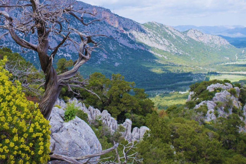
Foto : SARDEO
Technical data:
- Path type: stick or ring
- Distance: about 2 to 8 km (round trip)
- Altitude difference: from 250 to 500 metres s.l.m. approximately
- Duration: about 2 to 4.5 hours
The route requires good training and fitness. Hiking boots, long trousers and adequate water supply are recommended. It is advisable to bring a backpack with a hat, a garment or an accessory that protects against water, such as a raincoat or a parasol, food or snacks and a change to leave in the car.
The difficulty “E” of a hiking route indicates a level of a certain degree of difficulty.
According to the International Tables and Codes (CAI) to indicate the coefficient of difficulty of mountain excursions, a hiking path marked by the letter E means that these are itineraries that usually take place on the trails, or on traces of passage in various terrain (pastures, debris, rocks), usually with signals, there may be short flat or slightly inclined sections of residual snow, when, in the event of a fall, the slide stops in short space and without danger. They sometimes develop on open terrain, without paths, but not difficult, always with adequate signals. They can take place on steep slopes, the exposed sections are protected (barriers) or secured (cables).
They can have single passages on rock, not exposed, or short, not tiring or demanding, thanks to equipment (ladders, rungs, cables) but do not require the use of specific equipment (sling, carabiners, etc.).
They require a good sense of direction, as well as some experience and knowledge of the mountainous territory, training in walking, as well as adequate footwear and equipment.
You can also bring children from 6 years, provided they are used to walking and healthy.
Visiting hours at the Archaeological Park of Tiscali
-From January to April: 9.00 – 17.00
- May to September: 9.00 – 19.00
- October to December: 9.00 – 17.00
Tickets:
- Full price: €5
- Reduced price: €2.5
The ticket is also used to visit the Archaeological Museum of Dorgali.
To tackle the trekking on Mount Tiscali, it is advisable to book a guided hiking route, through expert guides. There are several proposals offered by the various tour operators on site, specialized in trekking, so you are spoiled for choice. This precaution is particularly important considering the difficulty of the route.
How to get to Monte Tiscali
By train:
The nearest railway station is Nuoro. However, from here you need to rent a car or take a taxi, since the site is about 25 km away.
By car:
- From Nuoro: follow the Provincial Road SP58 and then the SP46 towards Strada per Su Gologone/Lanaitto in Oliena. Continue towards Strada per Valle di Lanaittu for about 10 km.
- From Cagliari: follow the E25/SS131 towards Centrale Nuorese towards Strada Statale 389 Var di Buddusò and Correboia Nuoro. Take the exit for Nuoro/Tortoli’ and then follow the Circonvallazione Sud, SP22, SP46 and Strada per Su Gologone/Lanaitto towards Strada per Valle di Lanaittu in Oliena.
By plane:
The nearest airport is Olbia.
Copertina : SARDEO